THE GIANT ELM
- Marc Pilon
- Jan 19, 2024
- 3 min read
Updated: Jul 17, 2024
In the 1950’s, the St Lawrence Seaway and Power Project and inundation meant that thousands of trees had to be cut to clear the landscape and also to prevent them from eventually going into the turbine shoots of the proposed Moses-Saunders Hydro Electric Dam at Cornwall. Many of these remaining stumps dot the shoreline as a reminder that the St. Lawrence River west of Guindon Park up to Morrisburg is not a regular river system. In many of the shallow bays this project created, or when our water levels drop, they appear to be large boulders sticking out from the surface. Underwater, we’ll encounter countless stumps varying in size scattering the bottom. Often, the earth below them gets undermined by the waterflow and ice exposing a huge tentacle-like root system, these can be an eerie and a startling sight as you suddenly approach one of these formations.
The “Giant Elm” was situated in the village of Moulinette at the southern end of Avonmore Road, just south of the original Highway #2. It grew in a flat and open field near the waterfront and could be seen for miles from Highway #2 in either direction. Former residents still refer to “the Giant Elm” with fondness as memorable landmark of the area.
Canadian Nautical Charts #1433, Blue X marks the Giant Elm dive site, pine tree (P) logo is Lakeview Park
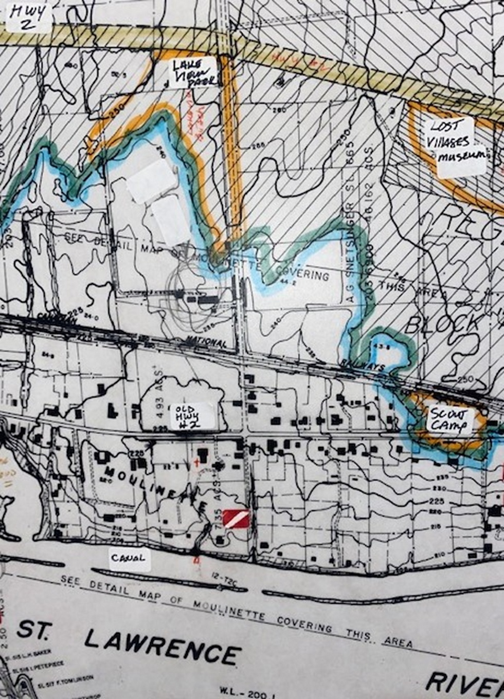
Topography Chart for the St Lawrence Power Project (1955), showing the Village of Moulinette pre-flooding. The Blue line is present day water levels, Green is land, Yellow is current Hwy #2, and Orange are area parks (#8 being Lakeview Park & Beach). The Dive flag show the location of the Giant Elm.
There are a few conflicting statistics about its official age and size (as noted in the above newspaper articles) but it is clearly the largest diameter tree stump that we have ever encountered diving the Lost Villages. The surrounding area has several smaller interesting stumps and piles of discarded tree trunks, but none as imposing as the Giant Elm. After many attempted dives to locate and mark this elusive site throughout the summer, once it was finally found there was no doubt about its identity. The sheer size and matching outline of the felled trunk in the first photo confirmed stump’s location. It now lies 24-28 ft deep (depending on the water levels), south of the point at Lakeview Beach Park (identified as Lakeview Heights). The Avonmore Road becomes the entrance to the parking lot for the beach. On Google Maps Satellite view, note the Road continues underwater faintly to the right of the Blue line, which may not be apparent when diving because it was a gravel road.
The best way to find this dive site is with a scooter (or Dive Propulsion Vehicle) as a good current flows eastward. Several attempts to anchor a boat at its GPS location failed as the bottom is flat and the current prevents a solid anchoring grab. Without a dive scooter you may have to contend with some very tall weeds between the old railway berm and old highway #2, this involves a South/West surface swim till they are behind you (depending on the time of year) before descending to the bottom. Keeping on the same S/W course, the current will arc you more southernly (Red line) where you will certainly come across some of the many remaining building foundations. The terrain is relatively flat with no noticeable drops until you reach the canal wall, at this point you will drift and follow it east till you hit a guide line we’ve strung from the edge of the wall north to the Giant Elm stump (light green line from dive flag, on the map). Next summer, our plan is to extend the guide line north to Old Highway #2 which will make it much easier to locate from the shoreline.
Marc Pilon, Andrew Emard, Sam Hamed, and Jason Xenakis


Great job! Thanks for laying a line. It will make it much easier to find. We measured it and confirmed the 10 feet diameter.
https://youtu.be/4E9ml6avEm4?si=GPu7ttsqUkhM5xQa